Introduction
Roman villas were high-status homes of wealthy landowners and sat at the heart of an estate. They are common throughout southern England and to a lesser extent in south-east Wales, with a few outliers in Carmarthenshire and Pembrokeshire and a singleton in the middle reaches of the Usk valley. Until 2010 Ceredigion had no known Roman villas, with archaeologists content to view large parts of west and north-west Wales as either within a 'military zone' or considered too unstable for potential villa-owners to invest long-term in Romanised forms of settlement, a 'native' mode remaining dominant throughout the Roman period.
The remains of a small late Roman villa have now been confirmed by excavation at Abermagwr near Aberystwyth, demonstrating the establishment of at least one Romano-British farming estate far beyond the previously known limits of villa-building in Wales. The discovery raises significant new questions about the regional economy and society of late Roman Wales, raising the probability of other villa discoveries in the heartlands of mid- and north Wales. The purpose of this short note is to describe the background to the discovery and excavation of the villa and to describe some of the key discoveries to date. As it has been compiled immediately after the second season of excavations, with a good deal of post-excavation processing and analysis awaited, what is currently presented here is likely to be refined and possibly even amended.
Discovery of the villa
Abermagwr lies towards the northern edge of the Trawsgoed basin in north Ceredigion, where the Ystwyth valley opens to form a broad, level gravel basin measuring some 1.7 km east-west by 3.5 kms northwest/southeast. Trawsgoed Roman fort lies at its centre, on the eastern bank of the Ystwyth. A mile distant from the fort, the north-west corner of a double-ditched enclosure at Abermagwr had long remained a puzzle, since its discovery as cropmarks through aerial photography in 1979. It was photographed from the air on several occasions thereafter but could not be assigned a definite date. In 2006 Royal Commission aerial photography revealed the whole of the 1.1 hectare enclosure, together with the footings of a stone building in one corner (Fig. 1). Though this caused some excitement it was another three years before the opportunity to take the discovery forward arose.
In 2009 a geophysical survey commissioned by RCAHMW of what was then postulated to be either a villa, a Roman temple or possibly even a medieval building. This unexpectedly revealed the plan of a 22m long winged building. Although the plan was characteristic of a Roman villa, and the building would have been confidently identified as such in south Wales or southern England, it was both unusual and unexpected in mid Wales. For this reason a two-week trial excavation was undertaken in July 2010 by the authors and funded by the Cambrian Archaeological Association (CAA) with logistical support from the Dyfed Archaeological Trust (DAT) and the Royal Commission (RCAHMW). This comprised a trench across the central part of the building, from north to south, with a second trench across the double ditches of the outer enclosure to its north. This confirmed the Romano-British date of the building though not of the enclosure ditches. A second season of excavation was undertaken for three weeks in July 2011. The previous year's excavation trench over the villa was extended, allowing a large part of the building to be properly examined. Smaller trenches were also dug through the double ditches of the enclosure, and at other points on the site with a view to answering particular questions. This work was generously again supported by the CAA, RCAHMW and DAT but with additional funding from the Department of Advanced Welsh and Celtic Studies, the Society for the Promotion of Roman Studies and the Society of Antiquaries.
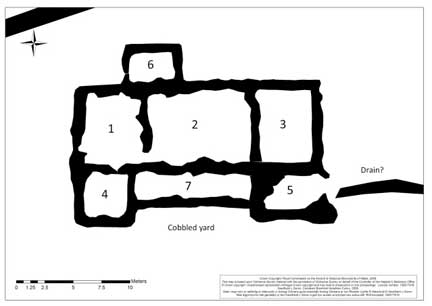
Plan of the Roman villa, derived from geophysical survey, showing room numbers used in the text (Crown Copyright RCAHMW)
The Romano-British building
The form and plan of the stone building, together with the finds (see below), demonstrated that Abermagwr had all the trappings of established villas elsewhere, including a slate roof and possibly glazed windows. It comprised a block of three main rooms measuring 22m east-west by 8m north-south, with a verandah and two projecting alae or wings on the south. A small room measuring 5m x 4m was later added to the rear of the building. In plan this was a distinctly Romanised building, architect designed, and probably commissioned by a wealthy local. Although it faces due south, it is oddly skewed in the upper north-east corner of the double-ditched enclosure leaving, or avoiding, a 'blank' area to the west. From excavations on Roman villas elsewhere we may expect a pre-villa phase of occupation, in the form of early timber buildings, or contemporary timber barns and byres. As yet any firm traces of these structures have proved elusive on the existing geophysical surveys but the 2011 section of the bivallate enclosure, in Trench D, to the east of the villa revealed a probable re-cut inner ditch. This suggests that the enclosure existed early in the history of the site, with the inner ditch being re-dug contemporaneously with the life of the house.
Whilst the nearby Roman fort at Trawscoed was abandoned by c.AD 130 at the latest, finds from the villa indicate occupation in the later 3rd and earlier 4th centuries AD showing continuing occupation. The finds include sherds of Black Burnished ware from Dorset and fine ware bowls from Oxfordshire. Three coins of Constantine I, minted in the first quarter of the 4th century AD, were discovered in 2010 and were crucial for the dating of the site, all being found lying on or near clay floor surfaces beneath roof collapse. Another two coins were found in 2011 and are presently awaiting precise identification.
The building was roofed with stone roofing tiles - referred to as 'slates' - split from local shale, forming the earliest known slated roof in Ceredigion. The majority were pentagonal, cut with five sides and a point forming a highly decorative roof, common elsewhere in Romano-British contexts. Triangular-trimmed slates from the very ridge were also recovered. Some of the slates were extremely heavy and a full report will elucidate some further details of the timberwork required to support their weight. The walls were built of local stone on deep cobble foundations as will be described below. It was previously thought that an upper storey, if such existed, may possibly have been timber-framed and of wattle and daub construction; however the quantity of quarried stone recovered from the site even after robbing makes a full stone elevation more likely. The villa was fronted by a cobbled yard of dumped river gravel, which was also found at the rear of the building bordering the enclosure ditches.
No convincing evidence has yet been found of any tessellated mosaic flooring or painted wall plaster. Despite an initial narrow trench, the 2010 excavations established that all the rooms examined were floored with clay, as was the verandah, whilst a stone-edged hearth was set into the west side of one room. Evidence for several other h, comprising areas of intense burning on the clay floor. In 2010 these were initially attributed to later activity but the relationship of the intensely burnt areas to a collapse of burnt roofing slates against the floor was not clearly established. However, the widening of the original trench allowed a far better opportunity to examine Rooms 2 and 6 revealing some unexpected details.
The main feature of Room 2 was the central slab-lined hearth 110cm x 95cm, floored with flat slates. Some 1.7m south of the hearth was a small circular clay-domed oven set against the south wall of the room (Fig. 6). Although cut by a later post hole and linear feature, likely to post-date the end of the villa, the western half survived measuring 60cm in diameter with a 35cm long throat, accessed from the north. It was here that meals would have been cooked and where, in 2010, a near-complete cooking pot was found broken alongside. The clay floor of Room 2 was carefully laid and gradually dipped in the centre towards the main hearth. One of the most interesting features observed on the floor were rectangular scorch-marks against the north wall. These may possibly be interpreted as the positions of fitted wooden benches or furniture which stood against the wall and were lost in a fire at the villa. These potential fixtures can be placed in context by a find from Room 6. As well as four glass beads found scattered across the floor, a fine bronze furniture fitting was also discovered giving us a vivid picture of the quality of Roman furniture in the building.
A further trench, Trench E, was opened in 2011 alongside the south-eastern ala to investigate a potential drain identified on the geophysical survey, considered to indicate a bathhouse. This trench was the most problematic, and revealed a large pit filled with dumps of building material and domestic rubbish, including quantities of Roman brick and tile. It may be that this was the construction trench for a heated room in a possible bathhouse, added to the south-eastern ala. Stone pilae (pillars) to support a raised floor of a hypocaust may have been inserted, but never completed.
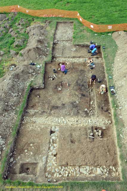
Overview of the villa excavations at the end of the 2011 season, looking north to south, with Room 6 in the right foreground, then the north and south walls of the villa (running left to right) defining Room 2, with the verandah beyond and finally the cobbled yard surface exposed at the narrow end of the trench (Crown Copyright RCAHMW).
The end of the villa
The 2011 season has shed light on the final years of the villa and how its abandonment may have come about. Excavation confirmed that part of the slate roof over Room 2 collapsed during a fire and fell onto the clay floor. Then at least one fireplace in Room 1 was built of roofing slates, some with their iron nails intact, demonstrating it was made and used after the villa roof had wholly or partly collapsed. An interesting late phase in the use of the villa is shown by a series of large postholes dug through the different rooms of the building; one or possibly two in Room 6, and two in the Room 2. A further linear feature, possibly a beam slot for a partition wall, had been dug across the verandah and into Room 2, destroying part of the oven. It may be that these show a sagging roof being propped up during the use of a ruinous building, or even footings for a new timber building erected within the ruins. This fragile evidence of a late Roman, or post-Roman, history of the villa is part of what makes the Abermagwr site so special. As the site has never been deep-ploughed, stratigraphic evidence survives here that has been lost from so many other villa sites in south Wales and southern England.
Building material and stone robbing
At the upper level, around 20cm below the plough soil, excavations initially encountered considerable quantities of quarried building stone and slates. Where the geophysical survey had shown Roman wall lines, voids in the rubble, infilled with smoother soil, were encountered. These turned out to be robber trenches, a feature of many archaeological sites where good quality stone was simply too precious a commodity to be left in a ruin.
In the 2011 season further, ruthlessly efficient, robber trenches which had excavated all quarried stones from the wall lines, were encountered. All that was left, and what were appearing as wall lines on the geophysical survey, were the hard-packed clay and river-cobble foundations of the villa's walls. The clay and packed stone foundations of the villa wall were found to be massive being some 60cm deep and packed with cobbles and boulders from the nearby river Magwr or Ystwyth. The construction of the foundations of the villa alone must have required hundreds of tons of material to be brought to the site. Only in one place had the robbers left a single block of wall stone in-situ, backed by clay-bonded cobbles, on the footing of the south verandah wall. It was barely 20cm below the topsoil. Robbing may have occurred when the nearby Trawsgoed mansion was under construction in the sixteenth century, as place-name evidence (see below) indicates that the villa was probably a standing ruin into medieval times. Two fragments of clay pipe stems recovered from the robber trenches in 2011 may yet give us a more precise date for the robbing episodes. The villa walls would have been prestigious prior to plastering (Fig. 7). A dump or collapse of original wall stones was found in Trench E along with several layers of dumping. These neat, squared blocks of locally-quarried stone give some impression of the quality of the original fabric. They may indeed have been robbed from the nearby site of the long-abandoned Roman fort at Trawsgoed, together brick and tile from its bathhouse. Several of the best blocks have been saved from the site for possible future museum display.
Historical and place-name evidence for the villa ruin
Two items of historical and place-name interest were noted during conversation with Gerald Morgan in 2009 and subsequently researched. The eighteenth century Trawsgoed Estate map shows part of the northern boundaries of the 'villa enclosure' fossilized in later field banks, prior to improvement and clearance to make one large field. The part of the field containing the villa is named 'Dol capel' suggestive of the site of a lost ecclesiastical building. Morgan also noted that the place-name Abermagwr contains the element 'fagwr' which can mean 'old ruin', or 'ruined homestead' locally, and may relate to the same building described by the 'Dol capel' name. The field containing the fort annex with its bath house and mansio outside Caer Gai Roman fort, Bala, is similarly called 'Cae Capel', and this seems show a preponderance for communities of the Middle Ages or thereabouts to assign a religious/church/chapel origin to visible ruins. Both names at Abermagwr suggest that the villa survived as a ruin or at least wall-footings into the medieval period. There may be wider patterns in the attribution or usage of place names to describe ruins which are of Roman date or character at this time than previously acknowledged. The Cornish villa at Illogan explored in the early 1930s lies on land at 'Magor Farm' in a field known as 'Chapel field' (O'Neil 1934 ). The parallels with Abermagwr are striking and hint at a greater role for place-name studies in the future identification of Roman sites in Wales and the west of Britain. Within Ceredigion at Fagwr-fawr, Dyffryn Castell, the undated rectangular earthwork at Llys Arthur, thought by JD to be a Roman fortlet, may require investigation in the future in the context of the discovery of the Abermagwr villa.
Conclusions
While the process of obtaining specialist reports on pottery, metalwork, glass, building material and environmental samples now begins, to unravel a more complete and closely-dated history of the villa, wider landscape questions also present themselves. A sub-ovoid single-ditched enclosure of Iron Age type in the field to the west of the villa, near Tan yr allt farm, may be a precursor and requires an evaluation trench to establish its chronology. The presence of a few sherds late 1st to early 2nd century pottery and brick and tile, including types normally found in hypocausted structures of similar date, raise issues as the nature of activity within the enclosure ditches prior to the construction of the stone villa building. On present evidence the stone building cannot be shown to predate the later 3rd century; therefore, pre-villa structures or settlement within the double-ditched enclosure cannot be dismissed. Whilst Abermagwr is presently the most north-westerly and isolated Roman villa in Wales, this is unlikely to reflect to the real situation. A thriving, prosperous, high status Romano-British farming estate would have possessed client farms and would have enjoyed a network of friends and neighbours in the wider landscape. Clearly we are not at the end of the story of late Roman settlement and farming in Ceredigion and mid Wales in general, but very much at the beginning.
Acknowledgements
The excavations would have been impossible without the permission and support of the landowner, Huw Tudor, the Secretary and Commissioners of RCAHMW and a number of enthusiastic volunteers who included L. Barker, D. Browne, H. Charnock, O. Davis, M. Duncker, S. Fielding, R Hamer, T. Jose, L. Leadbetter-Jones, B. Lewis, S. Lloyd, L. Osborne, S Pamment, C. Parry, O. Pritchard, D. Richards, S. Rodway, M. Ryan, H. Thomas, D. Thompson, and G. Ward.
Dr Toby Driver FSA
Aerial Investigator
Team Leader
Tim Rhagchwilio / Reconnaissance Team
Royal Commission on the Ancient and Historical Monuments of Wales
Dr Jeffrey L Davies
formerly of Aberystwyth University, Wales, and an authority on Roman Wales
Editor Note: My thanks to Dr. Driver and Dr. Davies for allowing me to use the above article and photographs,